Plane Table Survey
Plane table survey is performed by graphical method, in which plotting the map and taking reading at a same moment in the field.
 |
| PLANE TABLE |
- In other tour of surveys taking readings and map plotting is done separately in lab.
- Whether no need to lab to plot map we can perform both process taking readings and map plotting in field at same moment by plane table survey.
Principle of plane table survey:-
Plane table surveying is based on the principle that lines drawn plotting always lie parallel to the corresponding lines actually present on the ground.
Instrument used in plane table surveying:-
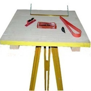
1. Plane Table:-
- Plane tanker has three types but most commonly Johnson Table is used.
- It is made up of depart wood.
- It's normal size is 60cm×75cm and it's thickness is aprox 15-20mm.
- It's upper surface on which drawing sheet is fixed should be smooth.
- An imaginary line which touch the top surface is known as Axis of Plane Table.
- It is used to support the sheet and to making graph.
2. Plumbing- fork or U- fork:-
- It is U- shaped instrument as fork, is one end it is sharped and another end having a hook, in which plumb- Bob is hanged
- Is sharp end is kept on the top surface of plane table.
- And it's another end having hook is keep below the plane table.
- It is used top centering Purpose in the plane table surveying.
- When it is fixed in standard situation on plane table an imaginary line joining both end of fork vertically.
3. Plumb-bob:-
- Plumb bob is an instrument which is used to centering purpose with plumbing fork.
- It is used to transferring any pint of ground surface on the sheet or graph.
4. Alidade:-
Alidade is an important instrument used in plane table survey.
There are two types of alidade:-
- Normal Alidade
- Telescopic Alidade.
- It is a type of scale which length varry between 60-75cm.
- It consist two vanes on both end of scale.
- Vane which is used to bisect the target with eye called eye- vane and other vane is known as object vane.
- The line joining eye vane and object vane is called line of sight.
- When the need of vanes it opened toward outside otherwise when it is not in use vanes can be folded inside.
- One edge of alidade scale is shapes on each measurement is graduated.
- Shaped edge of scale is known as ruling edge, graduated edge, fudicial edge or working edge.
- Normal alidade is used in the case of when ground surface to be surveyed is plane.
ii. Telescopic Alidade:-
- This type of alidade consist a telescope which move in vertical plane.
- Telescopic attached with compass on which angles are graduated, and compass is fixed vertically to the base of alidade.
- A scale is fixed with its base stand.
- It is used where field is undulated or in hilly area.
- It gives more accurate reading than the normal alidade.
 |
5. Indian Tangent Clinometer:-
- It's an instrument which taking the reading of vertical angle.
- It is used to find the angle of depression or angle of elevation from the line of sight in plane table survey.
- It is used in trigonometric survey.
6. Bubble tube:-
- It is an instrument used for leveling purpose in plane table survey.
- Bubble tube is used to keep plane table horizontally.
- Bubble tube consist a glass tube and it is filled with ether and alcohal liquid inside.
- It is kept on the plane table and tripod is adjust as to bring the bubble in middle of tube.
- When bubble is in center then we sure about plane table is levelled and now it ready to perform any operation.
- Bubble tube is kept on plane table while levelling in two situations; one time parallel to the x- axis and one time parallel to y- axis.
 |
Temporary adjustment of Theodolite
7. Trough Compass:-
- It is an instrument which help to find or locate north- south direction on plane table.
- It is used to orientation purpose in plane table survey.
- It can read maximum 5 degree of angle.
- It should be kept on right top corner on the plane table while it is used.
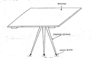
8. Tripod:-
- Tripod is an instrument which set the plane table on some height from ground level.
- It is an instrument of 3 legs which upper part is plane which is called levelling head.
- Plane table is kept on levelling head and fix by the fly nut and then operation is performed.
- It's height is approx 1.2m.
Setting up of Plane Table
Before the work in the field on the plane table, we have to perform some operations to fix the plane table in suitable situations.
Following operations are perform:-
i. Levelling
ii. Centering
iii. Orientation
1. Levelling:-
- Levelling is the process in which plane table fixed horizontally.
- Bubble tube is used to level the plane table.
- Bubble tube is kept on plane table in two right angled condition, and moved the plane table add in both condition till bubble I'd in middle of bubble tube.
2. Centering:-
- Centering is the process in which plane table isfixedin such a way the point on plane table is just over the ground station vertically.
- It is done with the help of plumbing fork and plumb bob.
3. Orientation:-
Orientation is the process in which all lines steer representing as they have parallel mean direction.
This process done by two methods:-
i. By Trough Compass
ii. By Backsighting.
1. By Trough Compass:-
- In this method we do parallel the north direction on plane table at each station by Trough compass.
- It is applicable only where there I'd no local attraction occurs.
- Local attraction affect the reading of Trough compass so that there error take place.
- This method is used under the following condition:-
- When there is no second point available for orientation.
- When the traverse is so long.
- In certain resection problems.
2. By Backsighting:-
- In this process plane table is fixed on station a and draw line ab to the b station on plane table.
- After that plane table is fixed on next station b and to draw the next traverse to keeping alidade on line ba and turned the table about vertical axis in such a easy that line of sight passed through station a.
- When line of sight passed through station a then line ab is coinciding with ground level and plane table will be oriented.
Method of Plane Table Surveying
1. Radiation:-
- To performing this method taking a instrument station T on the ground within a chain length from all the stations .
- And all the stations should be vehicle from instrument instrument T.
- To draw the map of area set the plane table at station T and mark the point t on the table after that sight the all stations from point t with alidade.
- And mark all the stations on their line of sight aft plane table with suitable scale.
2. Intersection:-
- Intersection method is performing when the distance between stations or instrument stations is too large or cannot be measured accurately due to some ground features.
- For this method two instrument stations are considered and all stations should be visible from instruments stations.
- Also both instrument stations are intervisibe.
- The line joining instrument stations is known as base line. Base line measured by invader tape for accurate length.
- To draw the map set the table at first instrument station and sight the base line with alidade.
- After draw base line mark the second instrument station on base line with suitable scale.
- Then draw line on table with alidade from first station to all stations.
- And after that set the tableaft second instrument station and orient the table by sighting base line.
- Then also sight the all stations to the second instrument stations.
- And join the intersection points of corresponding stations.
3. Traversing:-
When only adjacent stations are visible and no any station present on ground from where all stations are visible, then in that case traversing method is used.
Procedure of traversing:-
- Let four stations A,B,C and D.
- Set the table at station A and sight to its adjacent station B and mark tha point b on table with suitable scale.
- Then place the table at station B and orient the table by sighting line ba after that sight the station C and mark the point c on plane table.
- Again place the table at station C and orient the table then sight the station D and mark the point d on plane table.
- And last join the point d and a on the plane table.
- To check the accuracy of mapping set the table at station D and sight the station A , if station A, D and point a is colinear then, mapping is accurate.
- In closed traverse method mapping is completed on second lat station.
- If the area is narrow such as road, railway, canals, e.t.c; then there open traverse method is applied.
Advantage of Plane Table:-
- It is one of the most rapid method of surveying.
- It is economical than theodolite survey.
- Contour and other irregular objects may be accurately represented on the map since the tract is in view.
- The surveyor can check the accuracy of his work more frequently from any position he may desire, thus eliminating all error at the spot.
- No great skill is required in making satisfactory map.
- Field notes are not required, and this the possibility of mistakes in booking is eliminated.
- It is particularly suitable for filling in details in hilly areas and in magnetic areas where chain and compass survey are not suitable.
Disadvantage of Plane Table:-
- It is unsuitable for work in a wet climate, and is difficult in high wind.
- It is not useful for large scale surveys and accurate work.
- It is not suitable for surveying a densely wooded area.
- The absence of field notes is sometimes inconvenient if the survey has to be replotted to a different scale.
- Since there are so many accessories, there I'd every likelihood of these being lost.
Situations where Plane Table is used:-
The plane table surveying is indeed of the fastest and easiest methods of surveying. Plotting of plans and field observations can be done at the same time in plane tackle surveying. It is useful for the following cases:-
- It is best fitted for small scale surveying that is any types of field.
- It is also used in surveying industrial areas where compass survey fails to perform.
- It is often used to fill in details between stations fixed by triangulation method.


0 Comments